
From 04.11 To 04.15
01
2024.04.11
I. Pressure
Temperatures continued to rise, bringing warm weather throughout the day. Due to the influence of a high-pressure system, clear skies persisted. At 9 a.m., high pressure dominated the region, but by 9 p.m., low pressure was observed approaching from the south of the Korean Peninsula. While no precipitation occurred, southeasterly winds blew at 10–15 km/h. Although a low-pressure system was expected to move north on the 12th, no significant troughs or low-pressure effects were present on the 11th, and the high-pressure ridge maintained stable weather conditions.
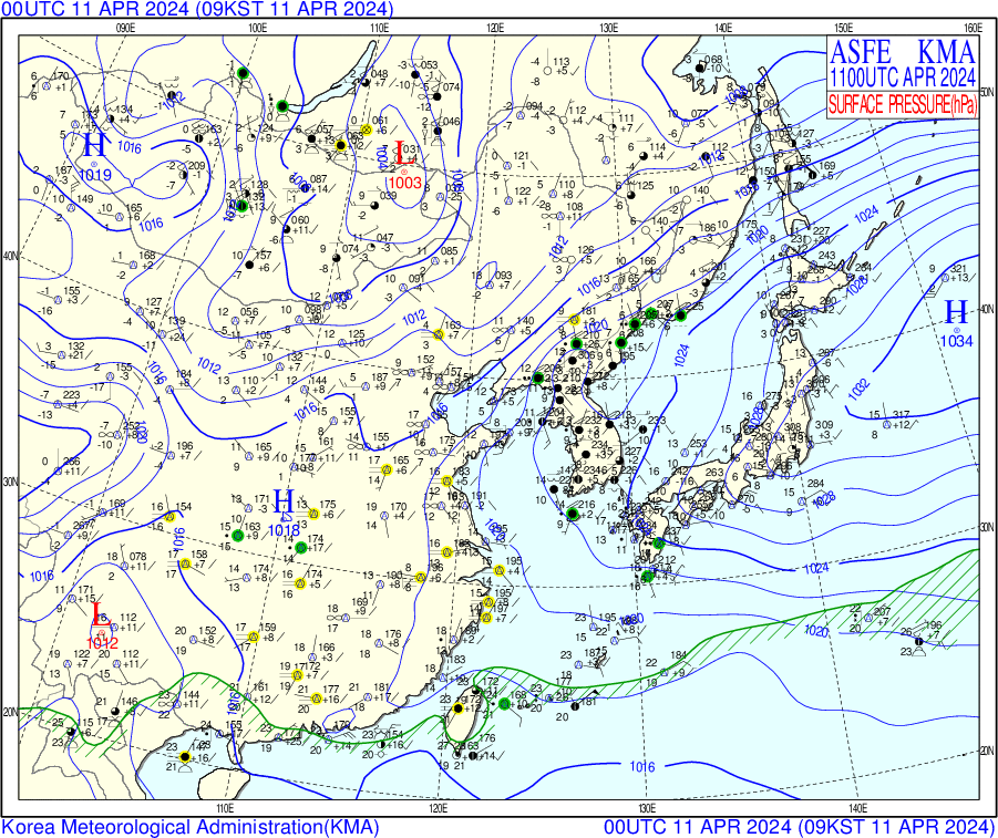
2024.04.11 surface chart 00UTC 2024.04.11 surface chart 12UTC
500hpa Upper-Level Analysis : A weak southwesterly flow brought relatively warm air over Seoul, consistent with cloudy conditions at the surface. This lowered atmospheric stability, likely contributing to cloud formation. A cut-off low was located over southern Mongolia and Inner Mongolia, with a trough axis extending north-south along the west coast of Korea. This generated positive vorticity advection (PVA) directly over Seoul and the Yellow Sea. As a result, showers, gusty winds, and wet snow in the mountains of Gangwon were reported from morning to midday across the capital region.Jet Stream Influence: Southwesterly winds ahead of the trough transported warm air below 3 km altitude, raising surface minimum temperatures by 3–4°C above average


2024.04.11 500hpa upper-level-chart 00UTC 2024.04.11 500hpa upper-level-chart 12UTC
850 hPa Upper-Level Analysis:A weak southwesterly flow transported relatively warm air over Seoul at the 850 hPa level. This aligns with cloudy surface conditions and suggests reduced atmospheric stability, which likely contributed to cloud formation.


2024.04.11 850hpa upper-level-chart 00UTC 2024.04.11 850hpa upper-level-chart 12UTC
2024.04.11 21 KST
II. Cloud & Precipitation
The satellite image below was captured using the GK-2A satellite. At 09:00 KST, mid- and high-level clouds were observed stretching north to south across the Korean Peninsula, suggesting a frontal or moist air band. Deep convective clouds were seen south of Jeju Island, likely associated with an approaching low-pressure system from the south.
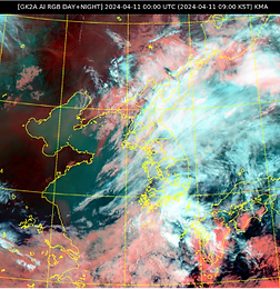
2024.04.11 GK2A RGB DAY+NIGHT 00UTC

2024.04.11 GK2A Cloud Type image 00UTC

2024.04.11 Radar in Baengyeongdo 00UTC
According to radar observations, 1–5 mm of rainfall was recorded in Seoul, the surrounding metropolitan area, and the Gangwon region.


2024.04.11 Skew T - Log diagram (Baengyeongdo)
At 09:00 KST, the dew point and temperature lines were very close between the 700 hPa and 400 hPa levels, indicating the presence of mid-level clouds.
At 21:00 KST, the LCL and CCL were significantly separated, suggesting that cloud formation through surface mixing alone was difficult. However, according to the 850 hPa weather chart, a northwesterly wind was blowing due to the pressure gradient between a low-pressure system to the south and a high-pressure system to the northeast. This inflow of cold air from the northwest could lead to cooling and potential atmospheric instability.
2024.04.11 850hpa upper-level-chart 12UTC

2024.04.11 15 KST
2024.04.11 18 KST


In the cloud distribution images at 18 KST and 21 KST, the cloud cluster can be seen moving southeastward.
2024.04.11 15 KST
2024.04.11 18 KST
2024.04.11 21 KST


At 15 KST, scattered rainfall was observed over the southeastern part of Gyeongsangnam-do and nearby seas, with some coastal areas experiencing heavy rain of up to 15 mm per hour.
At 18 KST, the intensity of the rain had significantly weakened, with only light precipitation remaining over the sea.
At 21 KST, the rain had completely dissipated, indicating that the atmosphere had gradually stabilized.
2024.04.11 21 KST
III. Temperature
2024.04.11 09 KST Skew T - Log diagram (Gwangju)


T max: 21℃
T min: 12℃


2024.04.11 21 KST Skew T - Log diagram (Gwangju)
02
2024.04.12
I. Pressure
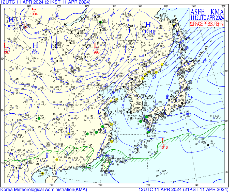
Clear weather persisted, but temperatures dropped slightly. A low-pressure system advanced from the south while another moved eastward from the northwest, placing the Korean Peninsula under the influence of low pressure. This resulted in relatively cloudy skies, though no precipitation occurred. Southeasterly winds blew at 10–15 km/h. Despite the low-pressure influence, a high-pressure ridge also passed over the region, helping to maintain overall stable weather conditions.
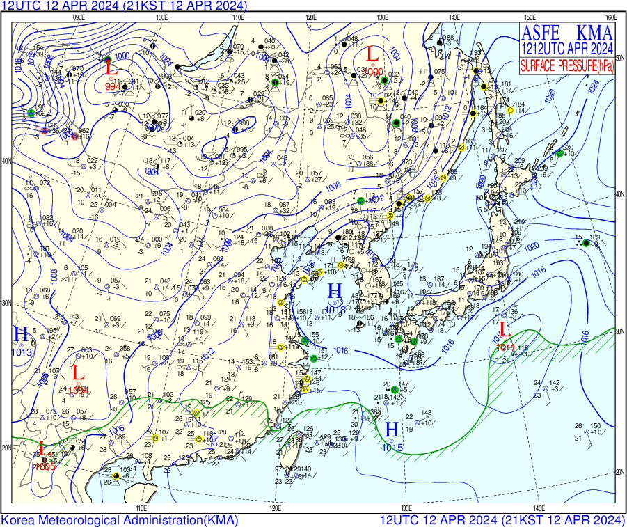
2024.04.12 surface chart 00UTC 2024.04.12 surface chart 12UTC
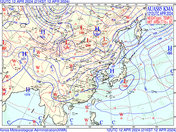
500 hPa Upper-Level Analysis : High pressure introduced dry and stable air aloft, consistent with clear skies at the surface. Increased atmospheric stability likely suppressed cloud development. An upper-level low moved eastward toward the East Sea (from Primorsky Krai to the Sea of Japan), placing Korea in the rear of a trough.The 500 hPa temperature over Seoul dropped sharply to around -27°C, which contributed to a significant drop in surface temperatures (as low as 8°C in the afternoon). Elevated terrain experienced atmospheric instability (CAPE ~300 J/kg), and localized convective activity led to sporadic snow showers and hail in parts of Chungcheong and western Gyeongsang provinces.A convergent zone at the tail of a northwesterly jet contributed to this localized activity, while surface low pressure weakened rapidly into a shallow trough by 12 UTC.


2024.04.12 500hpa upper-level-chart 00UTC 2024.04.12 500hpa upper-level-chart 12UTC
850 hPa Upper-Level Analysis :Under the influence of high pressure, dry and stable air was advected at the 850 hPa level. This corresponded with clear skies at the surface and likely contributed to suppressed cloud formation due to increased atmospheric stability.

2024.04.12 850hpa upper-level-chart 00UTC 2024.04.12 850hpa upper-level-chart 12UTC
II. Cloud & Precipitation

2024.04.12 GK2A RGB DAY+NIGHT 00UTC

2024.04.12 GK2A Cloud Layer/Level 00UTC
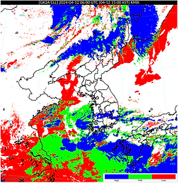
Using the GK-2A satellite imagery, low-level clouds were observed near Incheon.


2024.04.12 Skew T - Log diagram (Baengyeongdo)
The temperature and dew point lines overlap between the 1000 hPa and 925 hPa levels, indicating low cloud bases near the surface and the presence of low-level clouds.
The middle to upper atmosphere is stable, and the SSI index also indicates very stable conditions, suggesting low potential for convection.
At 21 KST, there are also areas near the 1000 hPa level where the temperature and dew point are nearly equal, suggesting a similar cloud type to that observed in the morning.

2024.04.12 GK2A Cloud image 09 KST

24.04.12 GK2A Cloud Layer/Level 15 KST
24.04.12 GK2A Cloud Layer/Level 17 KST
Clear atmospheric conditions near Seoul


2024.04.12 GK2A Cloud image 18 KST
2024.04.12 GK2A Cloud image 21 KST

At 21 KST, as a low-pressure system advanced northward from the south of the Korean Peninsula, a large rainband was observed moving northward over the sea south of Jeju Island. Additionally, localized intense rain cells were present within the rainband, indicating the potential for brief periods of heavy rainfall in some areas.
III. Temperature
2024.04.12 09 KST Skew T - Log diagram (Gwangju)


2024.04.12 21 KST Skew T - Log diagram (Gwangju)
T max: 24℃


T min: 11℃
03
2024.04.13
I. Pressure
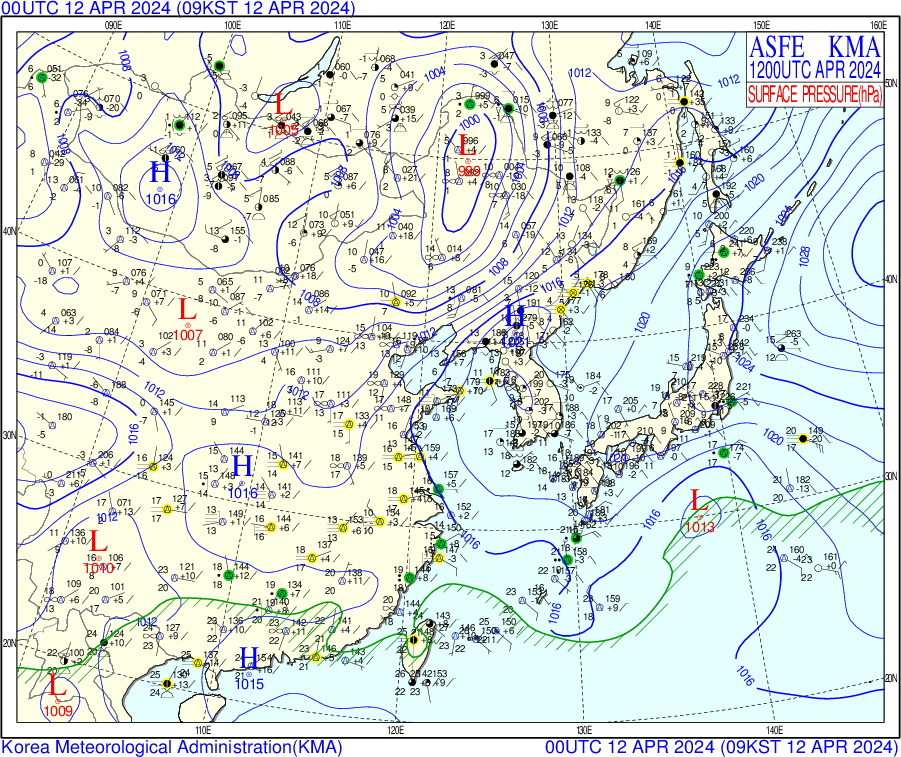
Cloudy skies and cooler temperatures continued, resulting in chilly weather. Influenced by a rapidly eastward-moving low-pressure system with strong pressure gradients, the Korean Peninsula shifted from high-pressure dominance to low-pressure influence. As a trough passed over the region, temperatures temporarily dropped and cloudy conditions persisted. No precipitation occurred, and northwesterly winds blew at 15–20 km/h.
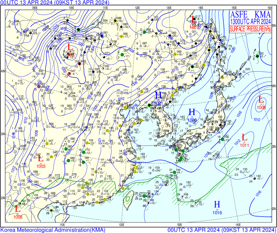
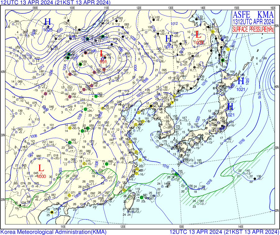
2024.04.13 surface chart 00UTC 2024.04.13 surface chart 12UTC
500 hPa Upper-Level Analysis: A continuous southwesterly flow brought warm air over Seoul, corresponding with high surface temperatures and clear skies. Increased atmospheric stability likely suppressed cloud formation. Following this, an upper-level high-pressure ridge extended from northern China to the western Korean Peninsula, causing an abnormal rise in geopotential height and rapid pressure increase around 00 UTC.The jet core fully shifted ahead of the trough, leading to atmospheric stagnation. Despite this, afternoon solar heating allowed temperatures to recover to a daily high of 17°C.


2024.04.13 500hpa upper-level-chart 00UTC 2024.04.13 500hpa upper-level-chart 12UTC
850 hPa Upper-Level Analysis:A persistent southwesterly flow brought warm air over Seoul at the 850 hPa level. This corresponds with high surface temperatures and clear skies, suggesting increased atmospheric stability that likely suppressed cloud formation.

2024.04.13 850hpa upper-level-chart 00UTC 2024.04.13 850hpa upper-level-chart 12UTC
II. Cloud & Precipitation

2024.04.13 GK2A RGB DAY+NIGHT 00UTC

2024.04.13 GK2A Cloud Layer/Level 00UTC

2024.04.13 09 KST Skew T - Log diagram (Baengyeongdo)

2024.04.13 Skew T - Log diagram (Jeju)
In the Skew-T diagram for Baengyeongdo, with a temperature–dew point spread (T–Td) of less than 5°C between the 1000 and 925 hPa levels, the presence of thin clouds such as low-level stratus clouds is possible.The middle to upper levels of the atmosphere remain stable, indicating limited potential for vertical development.
In the Skew-T diagram for Jeju, the wide gap between the temperature and dew point lines indicates a low likelihood of cloud formation. Additionally, the absence of an LFC (Level of Free Convection) at both 09 KST and 21 KST suggests that the atmosphere is stable, making it unlikely for strong convective clouds to develop.

2024.04.13 GK2A Cloud image 09 KST

2024.04.13 GK2A Cloud image 21 KST
Clear atmospheric conditions persisted across most parts of the country, and the weather was interpreted as dry with a very low likelihood of precipitation.
no precipitation
III. Temperature
2024.04.13 09 KST Skew T - Log diagram (Gwangju)

T max: 25℃

2024.04.13 21 KST Skew T - Log diagram (Gwangju)
T min: 12℃


04
2024.04.14
I. Pressure
Rainfall occurred as temperatures dropped further under the influence of a low-pressure system. The high-pressure system over the Korean Peninsula moved away, while low-pressure systems approached from the northwest and southwest, significantly affecting the region. This led to rainy and cloudy conditions. As a high-pressure ridge passed over the peninsula, stable weather was maintained afterward. No precipitation was recorded at the time, and southeasterly winds blew at 10–15 km/h.
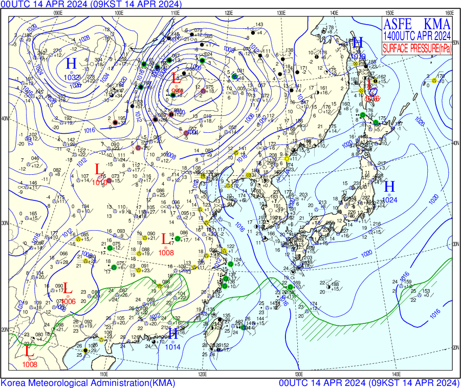
2024.04.14 surface chart 00UTC 2024.04.14 surface chart 12UTC
500 hPa Upper-Level Analysis: A strengthening southwesterly flow brought warmer air over Seoul, explaining the high surface temperatures and cloudy conditions. Increased atmospheric instability likely contributed to cloud formation.By 12 UTC, a long-period (7–8 day) trough over East Asia (around 100°E) began descending, initiating a cut-off low in northwest Manchuria. Ahead of the trough axis, a warm southwesterly plume developed.Temperatures at 500 hPa over Seoul dropped to -14°C, while surface temperatures reached 23°C. The atmosphere between 700 hPa and 850 hPa showed significant instability with a steep lapse rate (~7 K/km). In the evening, localized thunderstorms occurred in southern Gyeonggi Province, with three lightning strikes reported.Additionally, turbulent mixing (215 m/s) originating from the desert region of Inner Mongolia caused a temporary increase in PM10 (yellow dust) levels.


2024.04.14 500hpa upper-level-chart 00UTC 2024.04.14 500hpa upper-level-chart 12UTC
850 hPa Upper-Level Analysis:A strengthening southwesterly flow transported warmer air over Seoul at the 850 hPa level. This corresponds with high surface temperatures and cloudy skies, with increased atmospheric instability likely contributing to cloud formation.


2024.04.14 850hpa upper-level-chart 00UTC 2024.04.14 850hpa upper-level-chart 12UTC
II. Cloud & Precipitation
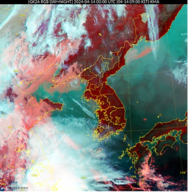
2024.04.14 GK2A RGB DAY+NIGHT 00UTC

2024.04.14 GK2A Cloud Layer/Level 00UTC

2024.04.14 GK2A Cloud image 00UTC
Under the influence of a high-pressure system, clear and dry weather persisted across most of the Korean Peninsula. Cloud type information from the surface weather chart also confirmed low cloud cover during this period.


2024.04.14 Skew T - Log diagram (Baengyeongdo)
No LFC was present, indicating a stable atmosphere that is not conducive to the development of strong convective clouds.Relative humidity remained low at around 50%, suggesting a dry atmosphere with no precipitation expected.
At 21KST, the temperature and dew point lines were close at the 400 hPa level, indicating the possibility of mid-level cloud formation.
2024.04.14 15 KST
2024.04.14 18 KST


2024.04.14 21 KST


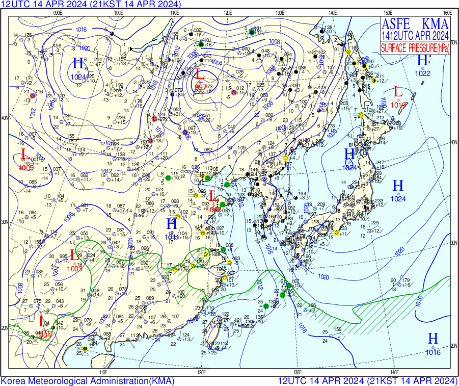
Warm air was transported over Seoul by a strong southwesterly flow, leading to increased atmospheric instability and the potential for cloud formation. As the high-pressure system over the Korean Peninsula shifted eastward, cloudy conditions developed across much of the region from the afternoon into the evening. However, rather than widespread rainfall, overcast skies persisted throughout the country.

2024.04.14 surface chart 12UTC
III. Temperature
2024.04.14 09 KST Skew T - Log Diagram


T min: 15℃
2024.04.14 21KST Skew T - Log Diagram


T max: 29℃
05
2024.04.15
I. Pressure
Rain continued, resulting in persistent cloudy weather under the influence of a low-pressure system. However, no significant trough or low-pressure center directly affected the region. A high-pressure ridge passed over the Korean Peninsula, maintaining overall stable conditions. No precipitation was observed, and southeasterly winds blew at 10–15 km/h.
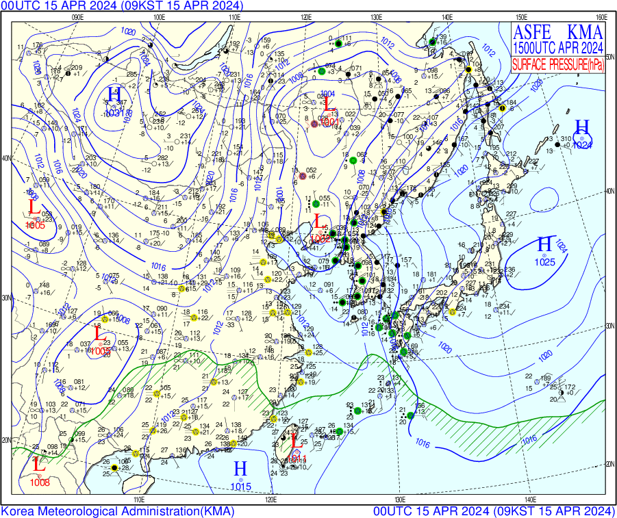
2024.04.15 surface chart 00UTC 2024.04.15 surface chart 12UTC
500 hPa Upper-Level Analysis: A persistent southwesterly flow maintained warm air over Seoul, explaining the high surface temperatures and precipitation. Atmospheric instability was maximized, likely contributing to rainfall.At 00 UTC and 12 UTC, an adiabatic cold core near Lake Baikal (southern Siberia) advanced southeastward, with Seoul’s 500 hPa temperature dropping back to -24°C by early morning.At 00 UTC, a low-pressure system approached central Yellow Sea, generating convective precipitation over the central sea by morning.By 12 UTC, the trough axis moved eastward into the East Sea, followed by the arrival of stable high pressure and the occlusion of the trough.Surface temperatures showed a large diurnal range, with highs around 18°C and lows near 4°C.


2024.04.15 500hpa upper-level-chart 00UTC 2024.04.15 500hpa upper-level-chart 12UTC
850 hPa Upper-Level Analysis:A persistent southwesterly flow maintained warm air over Seoul, corresponding with high surface temperatures and precipitation. Atmospheric instability was maximized, likely contributing to rainfall.Green dots indicating areas where the temperature-dew point difference (T–Td) was ≤ 3°C—signifying moist conditions—were widely distributed over the Korean Peninsula, suggesting a likelihood of continued rainfall.


2024.04.15 850hpa upper-level-chart 00UTC 2024.04.15 850hpa upper-level-chart 12UTC
II. Cloud & Precipitation
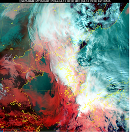
2024.04.15 GK2A RGB DAY+NIGHT 00UTC

2024.04.15 GK2A Cloud Layer/Level 00UTC

2024.04.15 GK2A Rainfall Rate 00UTC


2024.04.15 Skew T - Log diagram (Baengyeongdo)
With a relative humidity of 100% and both the LCL and CCL located very close to the surface, air can easily condense, making it favorable for the formation of fog or low-level stratus clouds near the ground. This indicates an overall cloudy and humid atmospheric environment, with the potential for light precipitation. The overlap between the temperature and dew point lines from 1000 to 850 hPa indicates that the air is nearly saturated, favoring cloud formation in the lower troposphere.
At 09 KST, based on the rainfall intensity image, the Korean Peninsula was under a widespread rainband, with moderate rainfall exceeding 10 mm/h observed particularly in the southern inland and parts of the central region.
2024.04.15 09 KST


2024.04.15 12 KST


2024.04.15 15 KST


At 12 KST, the rainband had gradually shifted eastward, resulting in the cessation or weakening of rainfall over the Seoul and the western coast. However, light to moderate rain continued in eastern Chungcheong, the Yeongseo region of Gangwon, and the inland areas of Gyeongsang Province, with rainfall rates generally around 5 to 10 mm per hour. Although the intensity weakened slightly, precipitation persisted over a broad area.
At 15 KST, most of the rainband had moved out over the East Sea, and rainfall had ended across much of the country. However, some light rain (around 1 to 4 mm per hour) lingered over parts of the eastern coasts of Gangwon and Gyeongbuk. From the west, skies began to clear, and signs of atmospheric stabilization became increasingly evident.
Overall, the rainfall on April 15 peaked in the morning, gradually weakened by midday, and mostly ceased by the afternoon. The weather transitioned to more stable conditions under the influence of a high-pressure system.

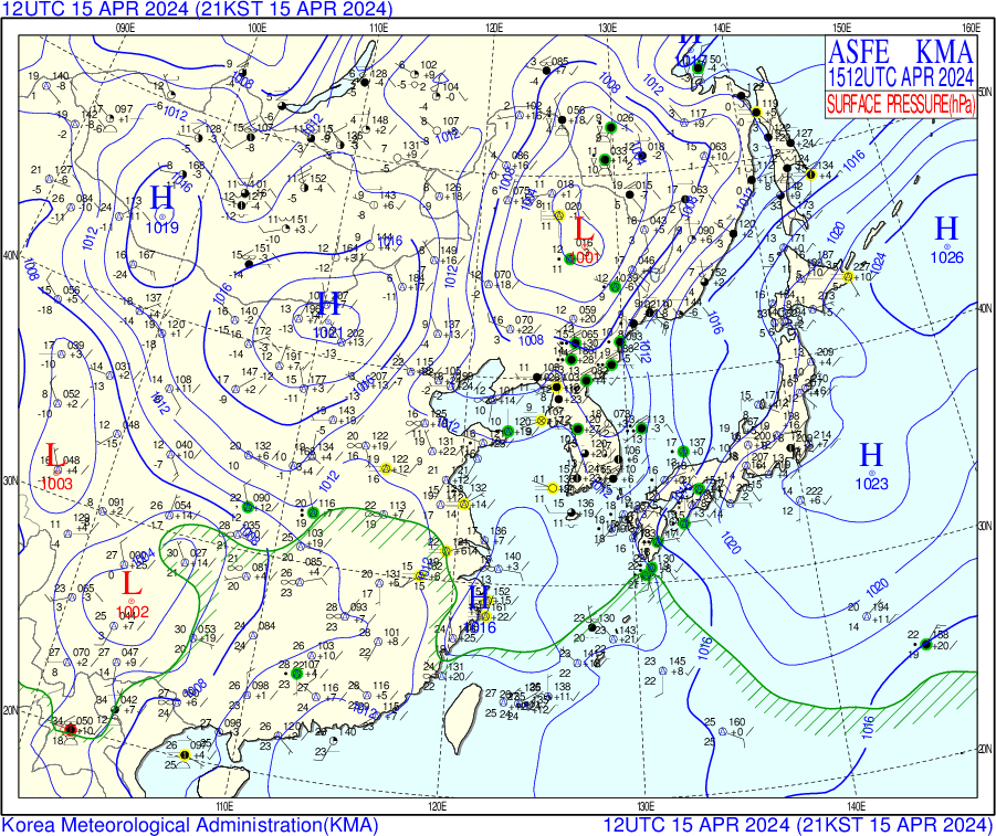
2024.04.15 surface chart 12UTC
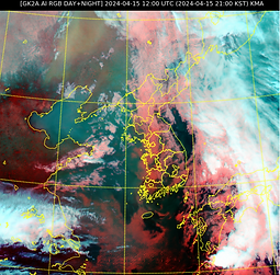
2024.04.15 GK2A RGB DAY+NIGHT 12UTC

2024.04.15 GK2A Rainfall Rate 12UTC
At 21 KST, extensive mid- and low-level clouds remained over the Korean Peninsula, especially in the eastern and southern regions. However, rainfall had mostly ceased, with only light precipitation observed along the east coast. Clearing skies were evident from the west, indicating stabilizing atmospheric conditions under the influence of a high-pressure ridge.
2024.04.15 21 KST Skew T - Log Diagram


T min: 16℃
T max: 21℃